
At the beginning of this year, Pelican of London cruises the Western Mediterranean Sea. I take this as a prompt to share some insights into the marine (eco)system of this region and its state of conservation.
For millennia the Mediterranean has been shaped by the rise and fall of civilisations and associated development in agriculture, art, philosophy, science and technology, by numerous wars and long-distance trade, by religious diversity and cultural fusion, and latterly by commercial rivalry and geopolitical competition, tourism and migration 1.
The Western Mediterranean Sea and its creatures know no national boundaries, cultural differences or politics, while their health is utterly dependent on international agreements and their implementation, maritime policies and traffic, as well as national environmental regulations, fishing practices and pollution from a wide variety of sources.
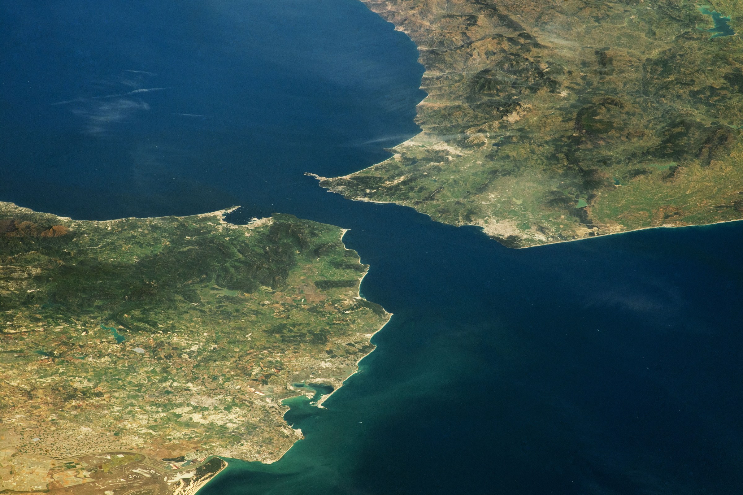
The Strait of Gibraltar has been known by many names, including Jabal al Tarik (from which the term ‘Gibraltar’ was derived), the very poetic Bāb al-maghrib (Gate of the sunset), Fretum Gaditanum (Strait of Cádiz) and the very unpoetic naval term STROG (as in STRait Of Gibraltar). These names reflect the gateway and strategic position of the Strait between Europe and Africa, connected to a sea with over 20 bordering countries and territories and passages into the Black Sea and Indian Ocean.
Physical characteristics
The Strait of Gibraltar connects the two water masses of the Mediterranean and the Mid-Atlantic. It was most likely formed by fluvial erosion of a land bridge some 5.3 million years ago, which allowed a trickle of Atlantic water to enter the Mediterranean basin. Over time, the water eroded bigger and deeper channels, allowing more and more water to enter and eventually fill the basin to create the Mediterranean Sea 2, 3
Today, the Strait is about 33 nautical miles (nm) long, 7.7 to 22 nm wide and between 300 and 1,000 m deep. Its underwater terrain (bathimetry) is a complex system of valleys, peaks, ridges and mud volcanoes, shaped by the powerful, density-driven overflow from the Mediterranean at depth. The regional climate favours evaporation, which exceeds the inputs from precipitation and fluvial runoff. As a consequence, Mediterranean seawater has a higher salt content (salinity range S=36-38 ppt) than Atlantic waters (S=33-37 ppt) 4. The temperature of western Mediterranean bottom waters is fairly stable at just below 13 °C, while Atlantic surface waters range from 15-20 °C. Therefore, the saltier and colder bottom waters of the Mediterranean are denser than Atlantic surface waters (Figure 1).
The negative water balance of the basin means that the water level of the Mediterranean is about 1.5 meters lower than that of the Atlantic Ocean, and Atlantic water continuously replenishes the Mediterranean through the Strait at a rate of some 1 million cubic meters per second (1×10⁶ m3/s) 2. Without this input, the Mediterranean would dry up within about 1000 years 3. Given the difference in water densities, the Atlantic inflow into the Mediterranean occurs at the surface, overlying the a forceful bottom current in the opposite direction (Figure 1).
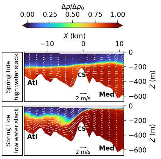
Figure 1: Graphical representation of the mean density and flow characteristics for the Strait of Gibraltar obtained from a combination of observations and modelling: a cross section of the Strait shows the mountainous sea bottom between the Atlantic (right) and the Mediterranean (left), with a horizontal distance axis X (in km). ‘CS’ marks the location of the Camarinal Sill. The colours indicate the difference in water density between the two water masses and the white arrows show the direction and velocity of the water movement during spring tide high water slack (top graph) and low water slack (bottom) 5. Extract from Fig 8 in Tassigny et al. 2026. https://doi.org/10.5194/os-22-459-2026.
The Mediterranean outflow is oceanographically important, as it contributes to the Atlantic Meridional Overturning Circulation (AMOC) and a range of currents along the eastern shores of the Atlantic Ocean 6. The water exchange through the Strait also fuels primary productivity, particularly in the Alboran Sea, located to the east of the Strait. Internal waves generated at the Camarinal Sill enhance vertical mixing, transporting nutrient-rich bottom waters into the sunlit shallower waters (euphotic zone), stimulating phytoplankton growth, thus fuelling the food web that supports the ecosystem, fisheries and regional economy.
Biodiversity
With over 17,000 reported marine species, the Mediterranean Sea is a biodiversity hotspot. The Strait and Alboran Sea host a mosaic of marine habitats, including reefs, seagrass beds, sandy substrates and fluvial fans, sea caves, canyons and gullies, sea mounds and escarpments.
Coastal and benthic (bottom-dwelling) habitats are rich in biodiversity, including bio-constructing fauna, such as gastropods associated with calcareous algae, reef-forming coral colonies and concretions by bryozoans. The region also features a range of protected species on the IUCN Red List, such as the rare red oyster (Spondylusgaederopus) and endemic species, such as the cushion star Asterina gibbosa or the deep water sponge Bubaropsis alborani 7.
Among the most common invertebrates are several species of squid and octopus, snail, clam and mussel, sea cucumber and coral, starfish and sea urchin, crab and lobster. No less than 19 colourful nudibranch species have been observed and nearly as many salps, jellyfish and related species 8.
From small coastal fish, such as shore clingfish, short snout seahorse, wrasse and weaver fish to commercially significant species, including anchovy, sardine, seabream, diverse species of tuna, barracuda and white marlin, this diverse habitat supports a wide variety of coastal and pelagic fish that attracts top predators.
Several IUCN‑listed threatened species of shark, including the blue shark (Prionace glauca) and the tope (Galeorhinus galeus) are among the 14 shark species that depend on the region’s pelagic habitats 9. Ten species of skate and ray, including the pelagic stingray (Pteroplatytrygon violacea), marbled electric ray (Torpedo nobiliana) and devil fish (Mobula mobular), are observed in the region 8. The highly endangered Mediterranean monk seal (Monachus monachus) is still sporadically observed here 7.
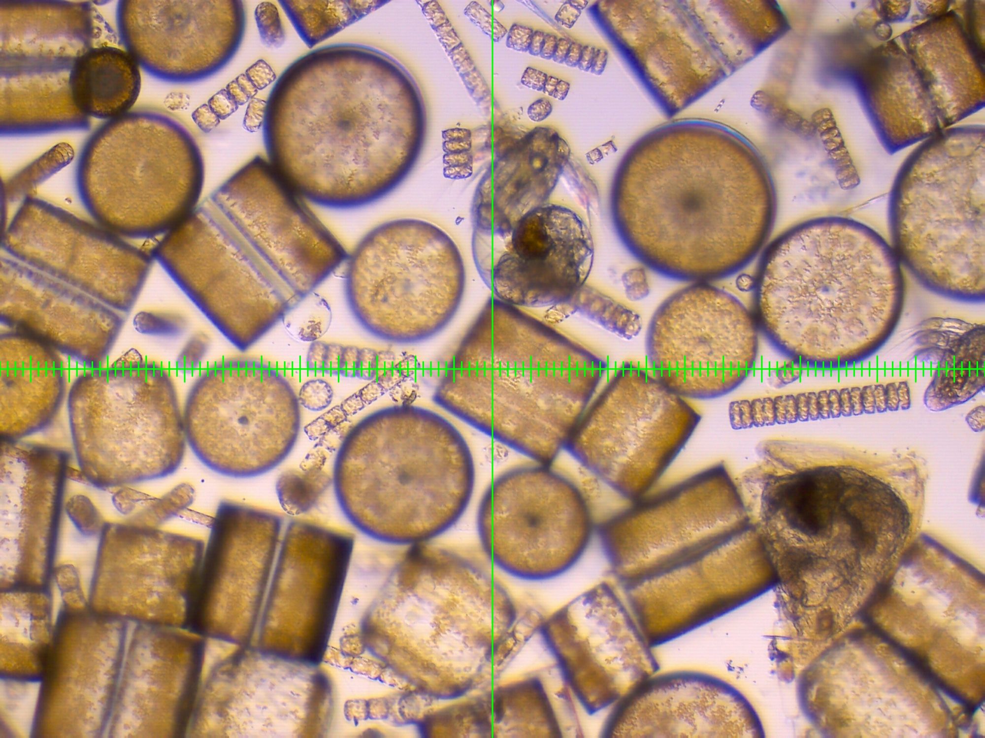
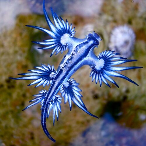
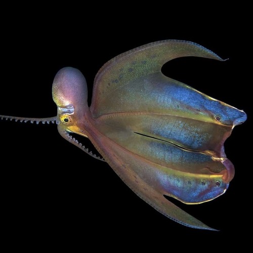
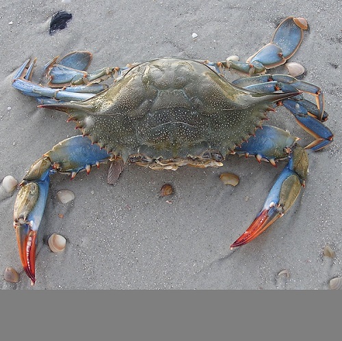
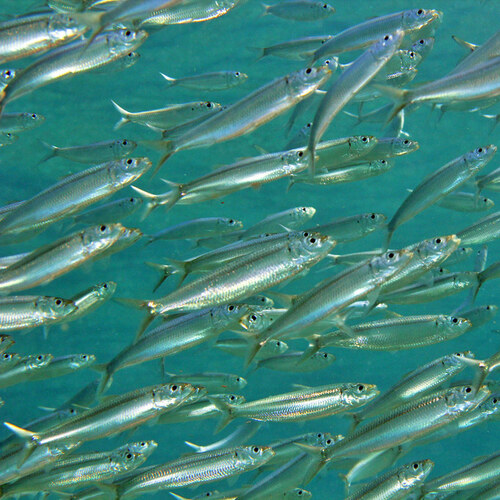
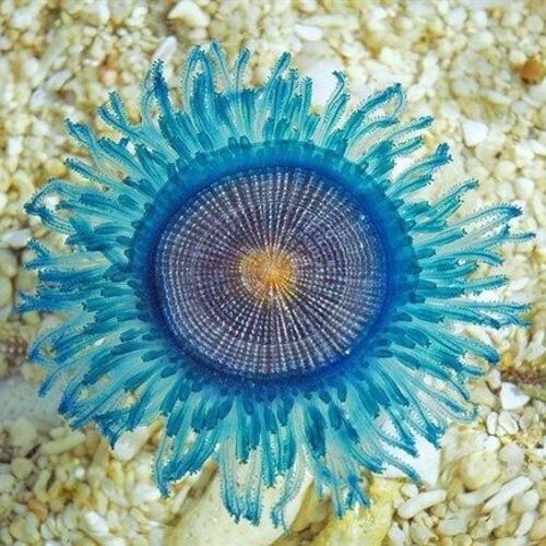
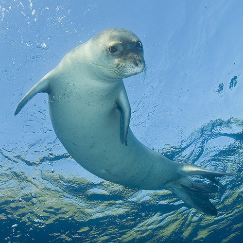
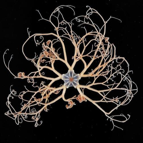
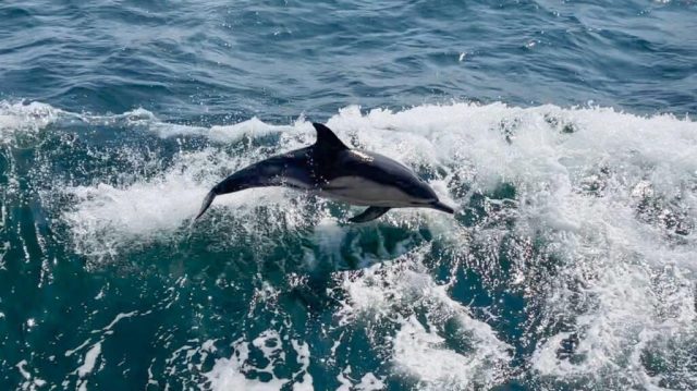
Figure 2: Commonly observed species in the Strait of Gibraltar and Alboran Sea. Top row: plankton, blue sea dragon, blue crab (an invasive species); middle row: common blanket octopus, round sardinella, blue button jellyfish ; bottom row: Mediterranean monk seal, basket star, common dolphin. All images, except plankton and dolphin, from The Nautilus Project (www.thenautilusproject.co/species-directory.html).
Cetaceans are among the most visible and iconic residents and visitors to the Strait. The Bay of Gibraltar provides feeding and calving grounds for striped (Stenella coeruleoalba) and common (Delphinus delphis) dolphins, while the Strait is an essential passage for fin whales (Balaenoptera physalus), sperm whale (Physeter catodon), pilot whales (Globicephala melaena), Cuvier’s beaked whale (Ziphius cavirostris), bottlenose dolphin (Tursiops truncatus), harbour porpoise (Phocoena phocoena) and orcas (Orcinus orca) 7.
The region is also a major migratory corridor for seabirds, such as Cory’s shearwater and northern gannets. The breeding seabird populations include several gull species, cormorant and osprey.
Threats
Northern Mediterranean shores have dense populations that are sustained by intense agriculture, fishing, industry, tourism, maritime trade and infrastructure development and associated pollution. Habitat loss and degradation in coastal zones destroy fish nurseries, decrease water quality and affect fish recruitment into the marine food web. In addition to competition for food through overfishing, the increasing urban development, draining of wetlands, infrastructure construction and light pollution pose threats to seabirds and their breeding grounds 7. Plastic debris at sea, oil spills, unregulated dumping of industrial and domestic wastes, runoff of agrochemicals and excess nutrient inputs are among the most concerning types of pollution regarding the general health of the marine environment 7.
With around 100,000 to 120,000 vessels traversing the Strait of Gibraltar annually, it is one of the busiest shipping lanes in the world (Figure 3). Associated with fouling and ballast water transportation, global shipping distributes marine alien species along its routes. In combination with aquaculture and the aquarium trade, this has resulted in nearly 1000 marine alien species to be introduced to the Mediterranean Sea by 2014, around half of which are established and spreading 9.
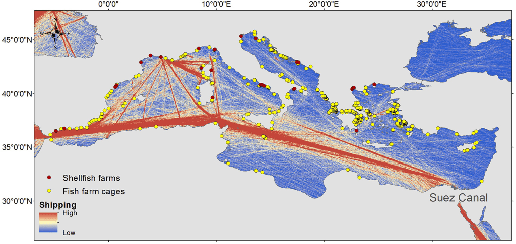
Figure 3: Map of the Mediterranean Sea, with indicators of maritime shipping intensity, locations of shellfish farms and large fish farm cages. Source: Figure 1 https://www.frontiersin.org/journals/marine-science/articles/10.3389/fmars.2014.00032/full.
Large, charismatic marine species are threatened by the fishing industry through overfishing of their prey, bycatch and direct takes, as well as collisions with ships. Entanglement in fishing gear, such as bottom and pelagic longlines, drift and bottom gillnets and bottom trawlers are the most common cause of drowning and death of cetaceans and sharks. Although dynamite fishing is strictly prohibited, it still occurs in some regions, causing extensive damage to rocky bottoms and coastal seagrass beds, as well as inhibiting feeding behaviour and causing injuries to marine mammals 7.
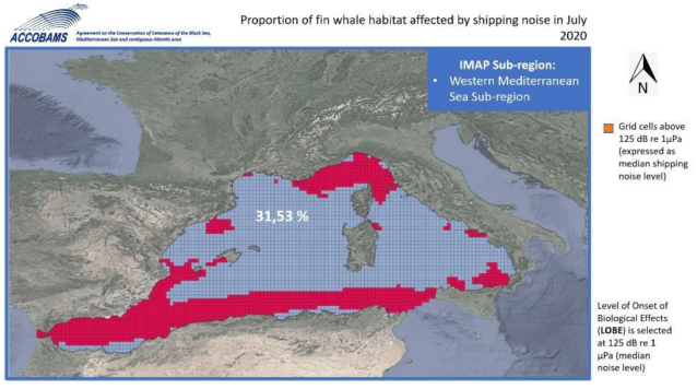
The acoustic disturbance from maritime traffic, military exercises, oil and gas exploration and marine construction affect normal cetacean activity in multiple ways. An assessment of noise levels in the Western Mediterranean Sea from marine traffic alone established that the Level of Onset of Biological Effects (LOBE) threshold of 125 dB was exceeded in 35% of the potential usable habitat for bottlenose dolphins and 31.5% for fin whales 10 (Figure 4). The report concluded that the Western Mediterranean Sea is non-tolerable for these two species selected for the study. It also pointed out that ocean noise affects the entire ecosystem and interactions between species, as excessive noise causes stress and can depress the immune response, but is also the most important sense for almost all marine animals in the context of communication, procreation, foraging and hunting, escaping predators and hazards, orientation and navigation 10.
Since the 1970s, air temperatures in the Western Mediterranean Sea increased by an average of 0.04 ± 0.023 °C each year, while the sea surface temperature has increased four times faster (0.12 ± 0.09 °C / year). Meanwhile, a reasearch station in Malaga, Andalucia, recorded sea level rise at an average rate of 8.7 mm per year since 1990. Along with temperature and saliinity changes at depth, these changes may affect oceanographic processes, such as the intensity of upwelling and supply of nutrients to the photic layer (sunlit part of the ocean), with potential reduction in primary productivity and carbon dioxide absorption. In turn, this may adversely affect the foundation to the food web with impacts to reproductive capacity within the ecosystem, as well as socio-economic activities in the maritime domain and coastal flooding 7.
The risks associated with climate change go beyond marine ecosystems: climate models for the Mediterranean Basin project warming rates 20% higher than global means and reduced rainfall. With a population of around 500 million people, decreasing rainfall, higher evaporation, drier soils and additional droughts and wildfires, as well as sea level rise will affect not only marine and terrestrial ecosystems, but also socio-cultural systems 11 (Figure 5).
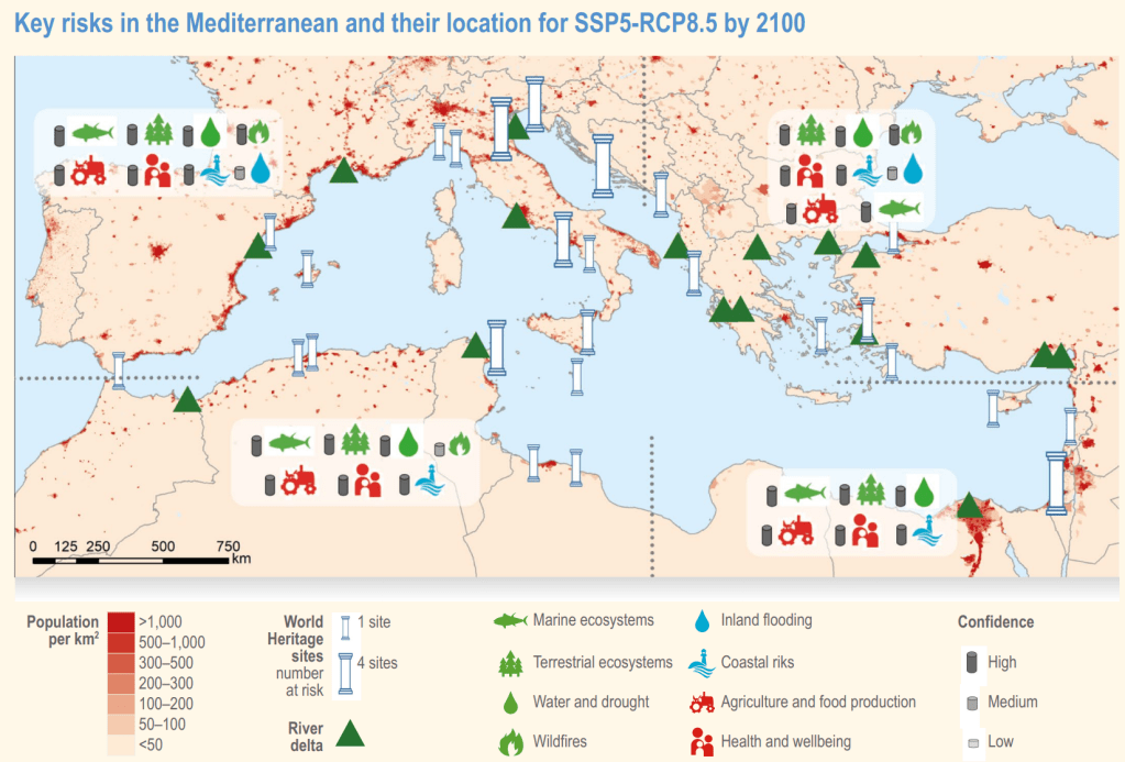
Figure 5. Key risks across the Mediterranean region by 2100. The symbols above the map highlight risks enhanced by climate change which apply to the entire region with high confidence. Other risks are localised in the map. IPCC Report AR6 WGII Figure CCP4_FAQ_4.1.1. doi:10.1017/9781009325844.021.
Designation and Conservation
The designation of coastal and marine areas is a tool to aid conservation, but not an end or solution in itself. Designations can help to channel resources towards the identification, protection and management of areas, specific habitats and/or species and ensure long-term ecosystem health and biodiversity. Designations, such as Marine Protected Areas (MPA) or Special Areas of Conservation (SPA) allow the regulation of human activities, such as fishing, shipping or development, but are no guarantee that such regulation (or its policing and enforcement) will take place.
As an example, MPAs are often subjected to multiple use and activities that demonstrably degrade ecosystem functioning continue to be permitted: just under 8% of the world’s ocean is currently protected by MPAs and bottom trawling remains permitted in almost all of them. On a positive note, the General Court of the European Union ruled in May 2025 that MPAs must be effectively safeguarded from harmful fishing practices, such as bottom trawling. It has created the European Oceans Pact to implement this ruling and safeguard marine protection in general 12. According to the European Climate, Infrastructure and Environment Executive Agency, MPAs “represent a core element of the European Union (EU) Biodiversity Strategy which aims to legally protect and effectively manage 30% of the EU marine waters by 2030“.
The Strait of Gibraltar overlaps or adjoins with a range of designations for marine waters:
- Over 10% of the Strait of Gibraltar and Alboran Sea are designated into around 45 MPAs (2026), with some overlap with other designations, including KBAs and others in this list 13,14
- 5 Key Biodiversity Areas (KBAs: Estrecho de Gibraltar, Tarifa, Ceuta, Strait of Gibraltar, and Jbel Moussa)
- Strait of Gibraltar and Alboran Sea Important Marine Mammal Areas (IMMA) 15
- Southern Waters of Gibraltar Special Area of Conservation/Special Protection Area (SAC/SPA) under EU Directives 16
- Ecologically or Biologically Significant Marine Area (Gulf of Cadiz)
- 5 Key Biodiversity Areas (KBAs: Estrecho de Gibraltar, Tarifa, Ceuta, Strait of Gibraltar, and Jbel Moussa)
- 6 Natura 2000 sites under the Habitats and/or Birds Directive (ES6120017, ES6120008, ES6310002, ES6120032, ES0000337, ES6120033)
- Ramsar site (Littoral de Jbel Moussa, also a UNESCO Biosphere Reserve and Natural Park) 17.
In addition, local conservation organisations, such as The Nautilus Project in Gibraltar 8, contribute significantly to biodiversity monitoring through citizen science and public education, documenting species such as rays, cuttlefish, sharks, seabirds, and marine invertebrates.
Key achievements of conservation efforts in the Western Mediterranean include the expansion expansion of the MPA network along the coasts of France and Spain, with most reaching good or high environmental status, biodiversity enhancement through no-trawl zones and steps towards the protection of endangered species and their habitats (e.g. sperm whales, porpoises, basking sharks, rays). The latter include 57 designated no-take MPAs in the Mediterranean and Black Seas, collectively covering just 3,742 km2 (0.14%) of the area and overlapping with just 10 Important Shark and Ray Areas (ISRAs) 18.
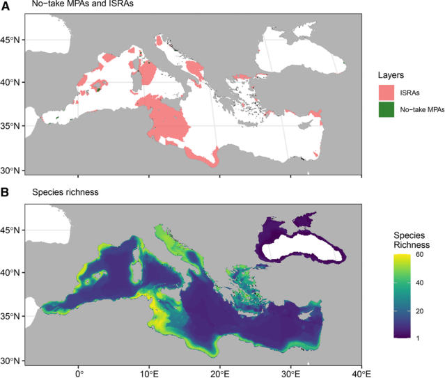
Figure 6. (A) Important Shark and Ray Areas (ISRAs) in the Mediterranean and Black Seas (red, n=65, combined area 16.2% of the MPA planning region) and all no-take MPAs (green, n=57, 0.14% of planning region. (B) Species richnes of chondrichthyans (sharks, rays, skates) in a sliding scale from low (purple) to yellow (high). Adapted from Figure 1 in Rhoner CA et al. 18.
Notwithstanding the efforts of all local initiatives and international designations, many challenges to ecosystem health of this region remain. Hopefully, the European Oceans Pact, who declared Africa as a key partner, will bring trans-boundary and trans-continental collaboration for marine protection into sharper focus and lead to the cessation of destructive fishing practices and habitat degradation.
Meanwhile, the designation of protected areas alone will not achieve the recovery of the ocean. Fundamental to the success of conservation is what these days is blandly known as ‘stakeholder engagement’. For ordinary people, fishers, industrialists, shipping magnates, farmers, naval ratings and officers, children, tourists, restauranteurs, politicians and influencers – it is as true today as it was in 1968, when the Senegalese forestry engineer and conservationist Baba Dioum said at a IUCN conference:
In the end, we will conserve only what we love, we will only love what we understand, and we understand only what we are taught.
This is where education and outreach have their place, where the experience of blue spaces is a powerful way to connect and fuel the love and understanding of the ocean. This is where Pelican of London has positioned itself with its mission to nurture “…a deep connection with and understanding of the ocean, empowering ocean advocacy and stewardship…”.
Since 2019, ocean education has been integrated into sail training on Pelican of Lonon. We have come a long way since then and a pilot impact assessment of this initiative in 2025 provides first glimpses of evidence for a link between developing a marine identity, acquiring ocean literacy and becoming advocates for the marine environment with pro-ocean behaviours in our trainees. We are not limiting ourselves to British and Irish waters:
Pelican has partnered with Gaia First by hosting their first Mare Nostrum expedition in the Western Mediterranean Sea in autumn 2026. The mission of this expedition is to undertake multidisciplinary research and education at sea and connect with universities in ports located in eight of the 1,087 Marine Protected Areas along the shores of the region, including locations in Morocco, France, Tunisia, Italy, Spain and Monaco.
Gaia First is ‘piloting a global network of collaborative and innovative initiatives for planet sustainability’. Their three pillars ‘Empower’, ‘Protect’ and ‘Share’ encompass a holistic approach to problem solving that involves people and communities, ecosystems and critical infrastructure, as well as connecting knowledge with action.
References
- Sağlamer G. 2013. The Mediterranean Sea: Cradle of Civilization. United Nations UN Chronicle. https://www.un.org/en/chronicle/article/mediterranean-sea-cradle-civilization#:~:text=The%20Middle%20Ages%20were%20the,%2C%20art%2C%20science%20and%20technology.
↩︎ - FIRMM. no date. Strait of Gibraltar – Origin and Significance. Foundation for Information and Research on Marine Mammals. https://www.firmm.org/en/strait-of-gibraltar ↩︎
- Loget N, Van Den Driessche J. 2006. On the origin of the Strait of Gibraltar. Sedimentary Geology. https://doi.org/10.1016/j.sedgeo.2006.03.012 ↩︎
- NOAA. 2023. Sea Water. National Oceanic and Atmospheric Administration. https://www.noaa.gov/jetstream/ocean/sea-water. ↩︎
- Tassigny et al. 2026. A realistic physical model of the Gibraltar Strait. Ocean Science. https://doi.org/10.5194/os-22-459-2026. ↩︎
- Nochols MD et al. 2020. Climate-induced variability in Mediterranean outflow to the North Atlantic Ocean during the Late Pleistocene. Paleoceanography and Paleoclimatology. https://doi.org/10.1029/2020PA003947 ↩︎
- UNEP. 2021. Alboran Sea: Ecology and human activities. United Nations Environment Programme Mediterranean Action Plan. UNEP(DEPI)/MED WG.408/Inf.18. https://rac-spa.org/nfp12/documents/information/wg.408_inf18_eng.pdf ↩︎
- Nautilus Project. 2023. Species directory. The Nautilus Project. https://thenautilusproject.co/species-directory.html ↩︎
- Katsanevakis S et al. 2014. Invading the Mediterranean Sea: biodiversity patterns shaped by human activities. https://doi.org/10.3389/fmars.2014.00032 ↩︎
- Maglio A et al. 2025. ACCOBAMS Mediterranean Technical Assessment on Anthropogenic Underwater Noise. Ecological Objective 11 – Energy including underwater noise. 9th Meeting of the Parties of Accobams, Limassol, Republic of Cyprus. https://doi.org/10.70978/FGOD6973. ↩︎
- Figure CCP4 FAQ4.1.1 in Ali E et al. 2022. Cross-Chapter Paper 4: Mediterranean Region. In: Climate Change 2022: Impacts, Adaptation and Vulnerability. Contribution of Working Group II to the Sixth Assessment Report of the Intergovernmental Panel on Climate Change [Pörtner H-O et al. (eds.)]. Cambridge University Press, Cambridge, UK and New York, NY, USA, pp. 2233–2272, doi:10.1017/9781009325844.021. ↩︎
- Hutchins R. 2025. EU Court: Marine Protected Areas must be shielded from trawling. Oceanographic News on 22/05/2025. https://oceanographicmagazine.com/news/eu-court-marine-protected-areas-must-be-shielded-from-trawling/ ↩︎
- ECCIEEA. 2025. Mapping of MPAs and their associated fishing activities in the Mediterranean and Black Seas. European Climate, Infrastructure and Environment Executive Agency. doi:10.2926/2662518 ↩︎
- Ramirez AM et al. 2021. Marine Protected Areas and Key Biodiversity Areas of the Alboran Sea and Adjacent Areas. In book: Alboran Sea – Ecosystems and Marine Resources (pp.819-923) Publisher: Spriger-Nature. doi:10.1007/978-3-030-65516-7_25 ↩︎
- Marine Mammal Protected Areas Task Force. 2025. Alboran Sea IMMA. https://www.marinemammalhabitat.org/factsheets/alboran-sea/ ↩︎
- NATURA 2000. 2016. Southern Waters of Gibraltar. JNCC.gov.uk. https://jncc.gov.uk/jncc-assets/SAC-N2K/UKGIB0002.pdf ↩︎
- ISRA. no date. Mediterranean and Black Seas Region. Important Shark and Ray Areas. ISRA Factsheets. https://sharkrayareas.org/portfolio-item/strait-of-gibraltar-isra/ ↩︎
- Rohner CA et al. 2025. Important Shark and Ray Areas can inform conservation planning in the Mediterranean and Black Seas. iScience 28(8) 113192. https://doi.org/10.1016/j.isci.2025.113192 ↩︎
Image Credit
Post Featured Image: By NASA/NASA Earth Observatory – https://earthobservatory.nasa.gov/images/151478/the-strait-of-gibraltar, Public Domain, https://commons.wikimedia.org/w/index.php?curid=133637787
ed
